Tokyo University of Marine Science and Technology Japanese Contact Us Campus Map
HOME > Graduate School of Marine Science and Technology > Marine System Engineering, Master's Course > Ocean Environmental Technology > Applied Information Systems Engineering Laboratory
Marine System Engineering, Master's Course
Ocean Environmental Technology Power System Engineering Marine Mechanical Engineering Marine Cybernetics Marine Exploring and Utilization

Ocean Environmental Technology
Applied Information Systems Engineering Laboratory
Research laboratory: Applied Information Systems Engineering Laboratory
Laboratory philosophy: Aim at improvement in the productivity of sea production, economical efficiency, and safety.
Program outline: The research and the education that aimed at contributing to sea production by uniting the conventional positioning technology and IT technology at a tip are advanced such as GPS, low earth orbit communication satellites, RFID (IC tags), biotelemetry systems, and Geographic Information Systems (GIS).
Graduate School instructor(s):  Yoshinori MIYAMOTO (Professor)
Research topics:
(1)  Research for the sea production using a communication satellite
Related instructor(s): Toshiharu KAKIHARA, Yoshinori MIYAMOTO and Keiichi UCHIDA
Outline: This topic researches a system for collecting data (DCS: Data Collection System) on the position and monitoring records of a signal communicator placed in a remote location linked via a communications satellite. The research on management of the fish catch information using a low orbital communications satellite is advanced in particular. This research presents a new information management system for the verification of the chain-of-custody in tuna from tuna fishing boat to the market.
Figure 1. Sketch of the tuna catch information management system
(2)  Study on application of GPS ( Global Positioning System ) to fishery

Related instructor(s): Toshiharu KAKIHARA, Yoshinori MIYAMOTO and Keiichi UCHIDA

Outline: This research topic aims to apply the Global Positioning System (GPS) for such purposes as: productivity improvement and greater efficiency in fishery; safe marine navigation for fishing vessels and monitoring of fishery resource distribution; and for fishery resource management.
Figure 2. Superpositioning of fish-catch data onto three-dimensional topographic map of the seabed (Example of conger eel trap fishing in Tokyo Bay)
(3)  Research and development of the underwater acoustic positioning systems

Related instructor(s): Toshiharu KAKIHARA, Yoshinori MIYAMOTO and Keiichi UCHIDA

Outline: The research is the three-dimensional monitoring of the fish behavior and the shape of fishing gear using the underwater acoustic positioning systems. A n original underwater positioning system is developed. This system is advance development of the SBL (Short Base Line) system to use the ultrasonic transmitters (pinger).
Figure 3. Preparation of a buoy with hydrophone for underwater positioning
(4)  Study on application of RFID (radio frequency identification) system to fishery.

Related instructor(s): Toshiharu KAKIHARA, Yoshinori MIYAMOTO and Keiichi UCHIDA

Outline: In this study, we developed a new automatic system, comprised of a radio frequency identification (RFID) system and global positioning system (GPS), for monitoring fishing effort and effectiveness of effort in fishery using many pieces of fishing gear, such as hooks of longline. Recently, it was begun to use a RFID system for management of the landing tuna.
Figure 4. Attachment of IC tags to caught tuna
Recent principal master’s thesis topics:

Fundamental research relating to the application of RFID systems to on-site fishing vessel operations
Shape measurements of set-nets and box-nets using an ultrasonic undersea positioning system
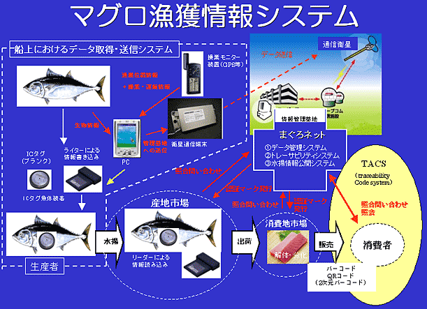
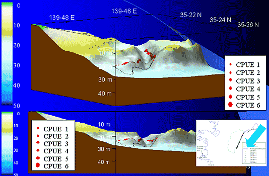
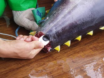
Tuna catch management system using communications satellites and GPS
Research relating to the transition of fishing catch information to a GIS format (for conger eel trap fishing in Tokyo Bay)
Worldwide monitoring of the position of fishing equipment using low earth orbit communications satellites